Yacht School
We started with a few hours of training – casting a line, tying off, and basic navigation – and then we were off. We spent our first hour on the water learning how to handle the boat. One turn of the wheel is about 10 degrees of rudder, and makes for a smooth turn. We started learning how to do slow speed (rudderless) maneuvering by shifting the direction of the port and starboard screws. Finally we were off – cruising at a smooth 8 knots – trying to steer a direct magnetic course. The boat will do about 20 knots, but we putting along at 8-9 most of the time. Once we got across the sound, near Bainbridge island, we picked up the course we had draw out in class. Each of us took a turn steering and navigating and all did ok. I came to realize how hard it is to keep track of where you are on your course, and I worked at this the rest of the trip.
We continued learning about navigation, reading a chart, using parallel rules, divider and understanding how to measure nautical miles. I think its really smart how one nautical mile equals to one degree of latitude. The part that I developed a lot of respect for is finding good waypoints on a course so you know when to turn. We then had dinner on shore at a pub right on the dock. We were in the mid ship state room- which was like sleeping in a double wide refrigerator box! But we managed.
Sunday morning we started with some more navigation, and then continued to develop our slow speed boat control. Practiced casting off, and learned a technique for getting of the dock when the wind is blowing you into it. We steered through a number of moored sailboats in the harbor. We learned a bit more about using prop walk when docking. Next we reviewed more navigation. We charted our course to Liberty Bay where we anchored for the night.
This time we had to use the charts that we plotted earlier in the day- I learned just how fast 8 knots is when you don’t know exactly where your going or where to turn. I finally got good getting a 2 point fix, and finding navigational beacons. All the time Debbie was doing the same thing – we rotated through stations on 20 minute watches. We learned how to use the radar to estimate distance, and track contacts. We did more close-in maneuvering, practiced holding steady about 2 feet from a piling facing into a wind. This is all practice for learning how to dock. We also started reviewing some of the navigational rules – and realized how many people on the water don’t have a clue.
We anchored in about 20 feet of water, in an area where the tide was about 12 feet. There were several seals playing around popping their heads out of the water. We put out about 125 feet of anchor chain. That’s 3 * (depth + tide + anchor height). We reviewed tides and current. This is very complex but if you have the right tide charts you can look up most of what you need. We also learned about some of the hazards that current can cause – like whirlpools. Whirlpools in Deception Pass can suck down a boat our size. The trick is planning your trip so you don’t go in areas where they form when the current is over 3 knots.
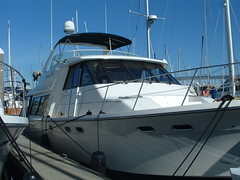
Interesting info about the boat – it was a 49 foot Bayliner twin screw diesel. It had three state rooms, 2 heads, a salon, pilot house, and flying bridge - about 40,000 pounds. We did most of our navigation work from the pilot house. We did all of our maneuvering on the flying bridge. We had a 16 NM radar, VHF, Depth, Compass, and GPS chart plotter – I found the combination of Radar and GPS really powerful. You can even see navigational beacons on the radar – it’s amazingly sensitive.
Monday was the best weather we had – it was crystal clear, you could see both the Olympic Mountains and Mt Rainer. Debbie took in the anchor, and we made our way to Port Orchard – across from the ship yard. We started using the GPS – oh man it takes a lot of the pain out of navigation – it can hold a heading perfectly – adjusting for currents, wind, and tide. Knowing how to do it on paper sure makes you appreciate how much more pleasant the GPS system makes navigation. We got to practice docking and undocking – Debbie and I both were able to do it. We also did fueling and pump-out. We then motored back to Elliott bay practicing navigation - it was fairly busy so we got to test our knowledge of the rules of the water. We got back to the dock, tided it down, and hoped in the car. We got home, hugged the kids and then took Susan to the airport – Susan we so appreciate you coming up to watch the girls. They had a great time, and we thank you. Debbie did great – she handled the boat, learned the navigation, and even worked on her knots! Thanks for putting up with me!
posted by John at
3:11 AM
![]()
![]()

0 Comments:
Post a Comment
<< Home